About All Tours From Cusco ToursFrom Ollantaytambo ToursATV ToursAnd Machu Picchu ToursFrom Urubamba ToursPrivate ToursAnd Rainbow Mountain ToursMaras Moray Tours Directions Hours & Fees
Find Tours 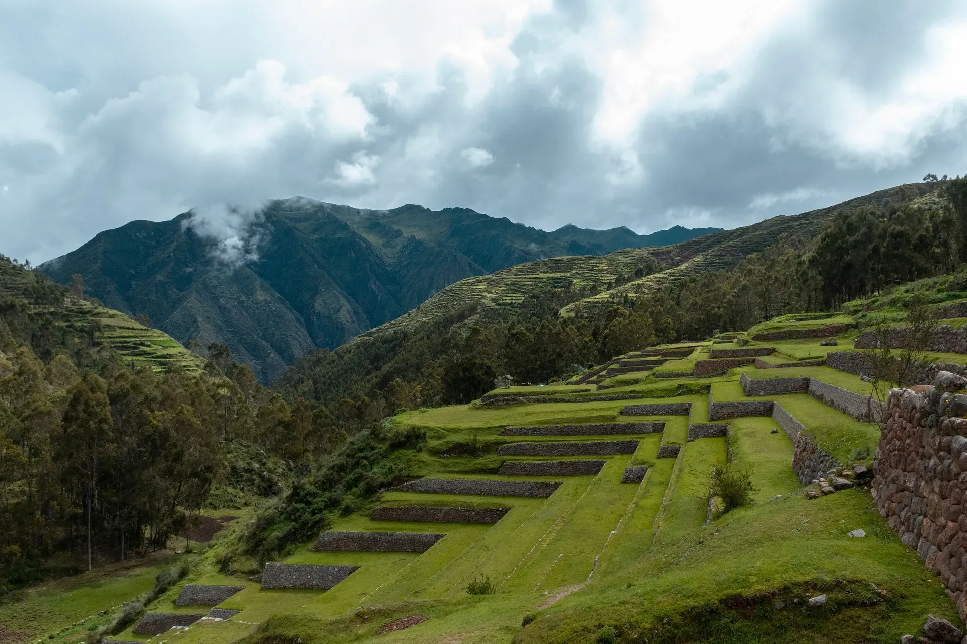
The Sacred Valley follows the Urubamba River for 62 miles through the Peruvian Andes, connecting Cusco to Machu Picchu. Ancient agricultural terraces, 5,000 salt ponds, and monumental stone fortresses define this 9,000-foot-high corridor.
The Sacred Valley follows the Urubamba River for 62 miles through the Peruvian Andes, connecting the towns of Pisac and Ollantaytambo just north of Cusco. The valley floor sits at 9,000 feet, flanked by mountain summits exceeding 16,000 feet. This lower elevation provides a natural acclimatization zone for travelers arriving from Cusco before they continue toward Machu Picchu. The landscape consists of steep gorges, river plains, and terraced hillsides that still produce maize and potatoes. Tributaries descend through adjoining canyons, irrigating the fertile soil that sustained the entire Inca Empire.
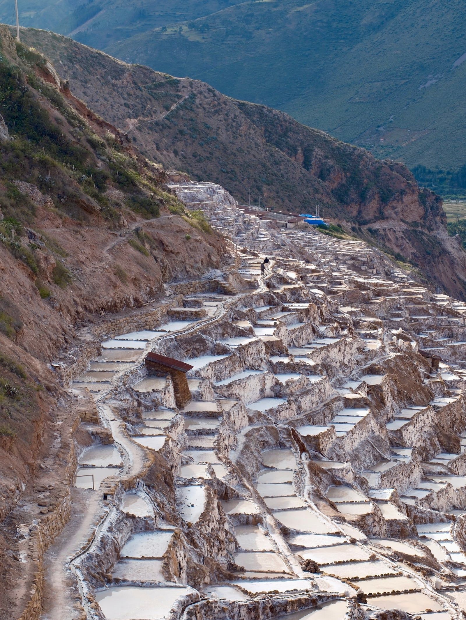
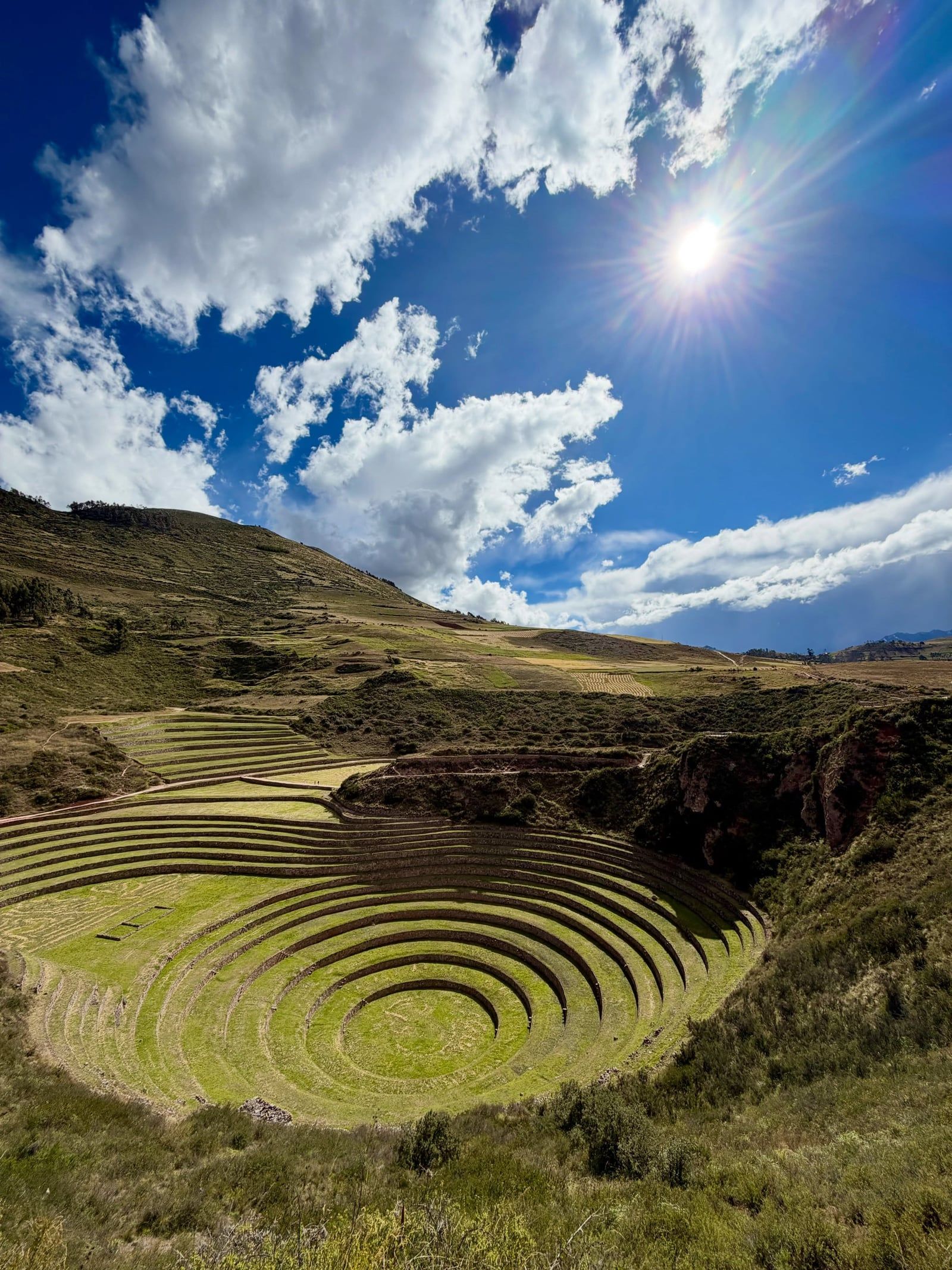
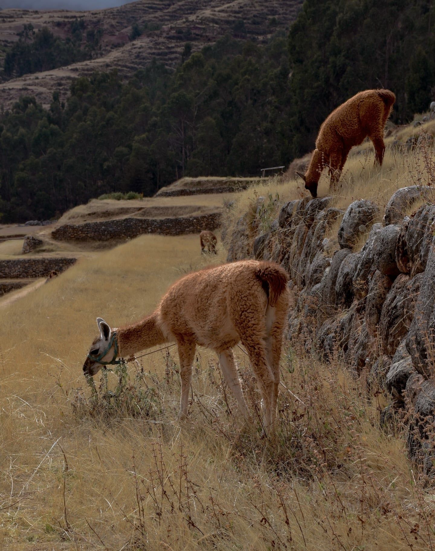
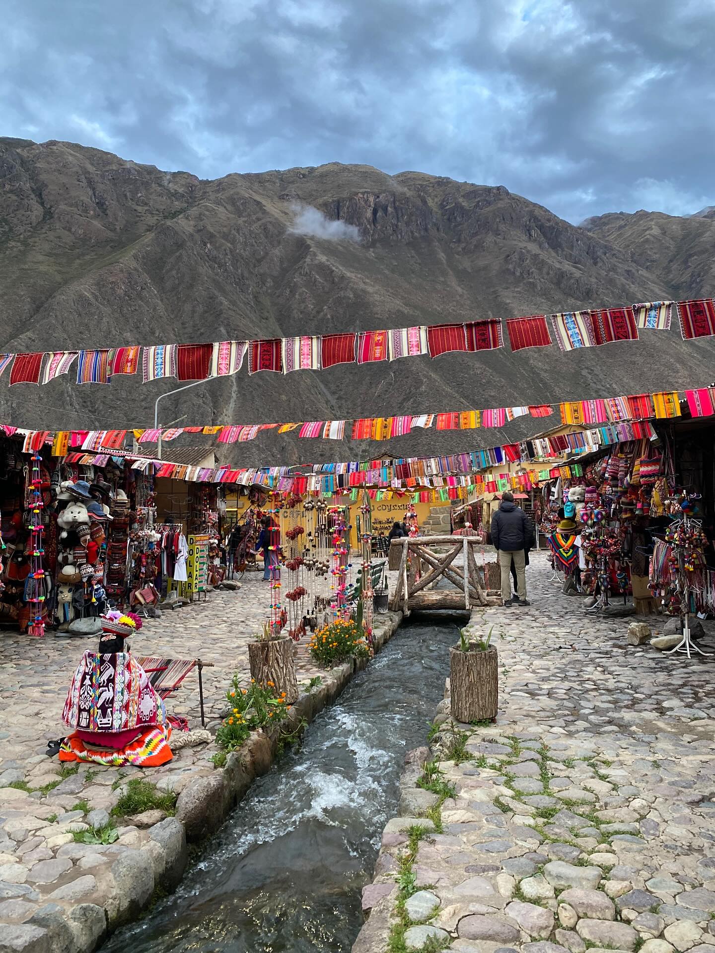
Visitors navigate a network of stone ruins, active agricultural sites, and high-altitude markets. The 10-day Cusco Tourist Ticket grants access to 16 major archaeological zones across the region. Travelers walk through the experimental farming terraces of Moray, where circular depressions create microclimates varying by 5°C. At the Maras salt mines, 5,000 individual evaporation ponds cascade down a canyon wall, yielding pink and white salt harvested by hand since pre-Inca times. In Chinchero, weavers demonstrate textile techniques using natural dyes near the remains of Tupac Inca Yupanqui's palace. The Cochahuasi Animal Sanctuary allows guests to observe rescued Andean black bears, pumas, and massive condors flying overhead.
Logistics require careful timing. The Poroy train station near Cusco closes entirely from January to April due to heavy rains and track maintenance, forcing departures from Ollantaytambo. Rain creates hazardous conditions on the steep stone steps at ruins like Pisac. Early morning arrivals between 7:00 AM and 8:00 AM beat the large tour buses and provide the best light for photographing the ancient masonry. Public colectivos depart frequently from Av. Huayruropata in Cusco, charging 15 to 20 Soles for the two-hour ride to the valley floor. Private taxis cost up to 100 Soles for a direct trip to Ollantaytambo.
Human habitation in the Urubamba River basin began around 800 B.C. with the Chanapata civilization. These early residents cultivated the fertile riverbanks, establishing agricultural practices that later groups expanded. The Qotacalla occupied the region from 500 to 900 A.D., followed by the Killke culture. Each successive civilization built upon the irrigation networks and terracing systems of their predecessors. The valley's moderate climate and reliable water supply from Andean glaciers made it a prime target for territorial expansion. Ceramic fragments and burial sites from these eras remain scattered throughout the lower valley, providing archaeologists with a timeline of pre-imperial occupation.
The expanding Inca Empire absorbed the valley between 1000 and 1400 A.D. Emperor Pachacuti transformed the region into the imperial breadbasket, directing the construction of massive agricultural terraces to maximize crop yields. The Incas engineered the Urubamba River, straightening its channel with stone retaining walls to prevent flooding and reclaim arable land. Pachacuti and subsequent rulers built royal estates throughout the corridor. Ollantaytambo emerged as a major administrative center, featuring sophisticated urban planning, aqueducts, and a formidable stone fortress built into the steep mountainside. Pisac developed into a defensive citadel guarding the southern entrance, complete with residential quarters and the largest known Inca cemetery in the region.
Spanish forces arrived in the 1530s, seeking control of the lucrative agricultural lands. In January 1537, the valley became a primary battleground. Manco Inca Yupanqui led a massive resistance force against a Spanish expedition commanded by Hernando Pizarro. The Incas utilized the high terraces of Ollantaytambo to rain arrows and boulders down on the conquistadors. Manco Inca then flooded the plain below the fortress, bogging down the Spanish cavalry and securing a decisive victory. This triumph proved temporary. Spanish reinforcements eventually forced the Incas to retreat into the jungle stronghold of Vilcabamba, leaving the stone cities of the valley abandoned to the elements.
Spanish colonization altered the valley's demographics and religion, but the physical infrastructure survived. Colonial churches rose directly on top of Inca stone foundations, visible today in towns like Chinchero. The agricultural terraces remained in continuous use, passing down through generations of Quechua-speaking farmers. Today, the Peruvian Ministry of Culture strictly regulates the archaeological sites. Drones and tripods are banned without special permits to protect the structures from damage and commercial exploitation. Visitors must purchase the Boleto Turístico to access the ruins, funding ongoing excavation and maintenance efforts. Guards patrol the major complexes, enforcing rules against climbing damaged walls or leaving designated pathways.
The Sacred Valley occupies a deep geological fault line carved by the Urubamba River. The valley floor sits at 9,000 feet, creating a temperate microclimate distinct from the freezing high-altitude puna above. Surrounding Andean peaks rise past 16,000 feet, funneling glacial meltwater down steep gorges into the main river channel. This constant water supply allowed the Incas to engineer complex hydraulic systems. Stone aqueducts and ceremonial fountains at sites like Tambomachay still flow with fresh mountain water, demonstrating precise calculations of gravity and fluid dynamics. The 30-meter Catarata Poc Poc waterfall drops through a lush canyon near Chinchero, fed by these same high-altitude catchment basins.
Inca masonry dominates the built environment. Builders utilized local basalt, limestone, and andesite, cutting multi-ton blocks to fit together without mortar. The fortress of Ollantaytambo features massive pink rhyolite monoliths, some weighing over 50 tons, transported from a quarry across the river and up the steep valley wall. At Pisac, agricultural terraces follow the natural contours of the mountain, supported by retaining walls that absorb solar heat during the day and release it at night to protect crops from frost. The sheer scale of these earthworks required thousands of laborers to move soil up the mountainsides, creating flat, arable land where none existed naturally.
The Moray archaeological site showcases earth-moving on a massive scale. Three giant circular depressions resemble amphitheaters carved directly into the limestone bedrock. The largest bowl reaches 30 meters deep. Temperature differentials between the top and bottom terraces can reach 5°C, allowing the Incas to test crop viability across different simulated altitudes. Further down the valley, the Maras salt pans utilize a natural subterranean saltwater spring. The highly saline water feeds into 5,000 geometric pools, each measuring roughly 4 square meters. The sun evaporates the liquid to leave behind thick crusts of halite, which workers harvest using wooden rakes just as they did centuries ago.
The Incas viewed the Urubamba River as the earthly reflection of the Milky Way. They aligned their temples, royal estates, and agricultural cycles with the movement of the stars and the flow of the water. The valley's geography dictated religious practices, with towering mountain peaks—known as Apus—worshipped as protective deities controlling the weather and water supply. Shrines and ceremonial baths dot the landscape, marking locations where the physical and spiritual worlds intersected. At Q'enqo, sacred passageways and a ceremonial altar carved into a massive natural limestone formation reveal details of ancient mummification practices.
Quechua communities maintain many of these ancestral traditions today. Farmers still cultivate native varieties of maize and potatoes on the exact stone terraces built by the Incas. In towns like Chinchero, women weave textiles using backstrap looms, dyeing alpaca and sheep wool with natural pigments derived from local plants and insects. The bright red dye comes from cochineal bugs crushed with lime juice, while blue tones originate from the tara plant. These textiles encode regional symbols and family histories into their geometric patterns.
Culinary practices also reflect the region's distinct identity. Roadside restaurants between Maras and Chinchero serve Manca chicharro, a local dish combining deep-fried pork, stuffed rocoto peppers, and large-kernel white corn. Strict regulations now protect this cultural landscape. Removing coca leaves from Peru carries severe legal penalties at international borders, despite their common use locally to combat altitude sickness. Authorities heavily fine anyone caught scratching graffiti into the ancient stone walls or damaging the delicate high-altitude flora.
The full Boleto Turístico costs 130 Soles for foreigners and grants access to 16 archaeological sites over 10 days.
The circular terraces at Moray create microclimates with temperature differences of up to 5°C between the highest and lowest levels.
The Maras salt mines consist of over 5,000 individual evaporation pools, each measuring roughly four square meters.
The Peruvian Ministry of Culture strictly prohibits all drone flights over archaeological sites, punishing violators with equipment confiscation.
The Poroy train station near Cusco closes entirely from January to April due to heavy rains and track maintenance.
The Incas considered the 30-meter Catarata Poc Poc waterfall near Chinchero to be the mythological birthplace of the rainbow.
Local roadside stalls serve Manca chicharro, a dish of deep-fried pork, stuffed rocoto peppers, and boiled white corn found only in this valley.
The valley floor sits at an elevation of approximately 9,000 feet (2,743 to 2,790 meters). This is significantly lower than Cusco's altitude of 11,150 feet. Travelers frequently spend their first few nights here to acclimate gradually and prevent altitude sickness.
The full Boleto Turístico costs 130 Soles for foreign adults and is valid for 10 days across 16 sites. A partial ticket covering only the Sacred Valley circuit costs 70 Soles and lasts for two days. Card payments incur a 3.15% transaction fee.
No, the Maras Salt Mines require a separate entrance fee. Visitors must pay 10 Soles in cash directly at the site gates. This payment grants access to the designated observation areas overlooking the 5,000 salt pools.
Shared vans called colectivos depart regularly from Av. Huayruropata in Cusco, costing 15 to 20 Soles for the two-hour ride. Private taxis hold up to four passengers and typically charge 80 to 100 Soles for a direct trip to Ollantaytambo.
Arriving at the archaeological sites between 7:00 AM and 8:00 AM provides the best experience. This early window allows you to avoid the large tour buses that arrive after 10:00 AM. The morning light also creates sharp contrasts on the stone masonry for photography.
Drones are completely banned over all archaeological sites in the Sacred Valley. Unauthorized flights result in immediate equipment confiscation and expulsion by site guards. Tripods and camera stabilizers also require a special commercial permit from the Ministry of Culture.
The flat valley floor and sites like the Maras Salt Mines offer good accessibility. Wheelchair users can also reach the main upper viewpoint at the Moray terraces. However, hillside ruins like Pisac and Ollantaytambo feature steep, uneven stone steps that restrict mobility access.
The Poroy station near Cusco shuts down from January to April every year. Heavy precipitation during the rainy season causes mudslides and requires extensive track maintenance. Travelers must book their Machu Picchu train departures from the Ollantaytambo station during these months.
The Incas used the massive circular depressions at Moray as an agricultural laboratory. The terraced design creates distinct microclimates, with temperatures varying up to 5°C between the top and bottom rings. This allowed farmers to test crop viability under different simulated altitudes.
Bring flexible clothing layers, a high-quality rain jacket, sunscreen, and a hat. Morning temperatures drop near freezing, but the midday Andean sun is exceptionally intense. Wear hiking footwear with slip-resistant soles to safely navigate the steep, uneven stone stairs at the ruins.
Browse verified tours with free cancellation and instant confirmation.
Find Tours